Into the Enchanted Mountains
A three-day drive from Cuenca into the high Serranía de Cuenca — rock cities, waterfalls and river springs, ending in the mountain village of Tragacete.
- DistanceAbout 70 km one way (Cuenca → Tragacete), plus local drives to the sights
- Duration3 days, 3 nights (with an optional 4th day from Tragacete)
- Route TypeLinear — the base moves with you (Cuenca → Uña → Tragacete). See “Why it runs one way” below.
- Best forCar (see the camper note in the FAQ)
- DifficultyEasy driving on quiet, winding mountain roads; short, gentle walks to the sights
- Best seasonLate spring and early autumn for water and colour; summer is green and cool; winter is snowy and beautiful but cold
- ThemeNature — karst rock, springs and pine forest
- Start / end pointStart in Cuenca; end in Tragacete (nearest airports: Madrid, then Valencia)
Why this Route Exists
Most people who reach Cuenca see the famous hanging houses, take their photo, and drive on. They miss the best part. Just north of the city, a single mountain road climbs into the Serranía de Cuenca. It leads into a world of pale limestone, deep river gorges and pine forest, where rock has been carved into shapes that look almost alive. This route follows that road for three unhurried days. You start in a striking UNESCO city. Then you trade it for rock “cities”, clifftop viewpoints, a hidden lagoon, and the cold, clear springs where two of Spain’s great rivers are born. It stays quiet because it has no airport of its own and no coast. You have to want to come here.
Rock shaped like a dream
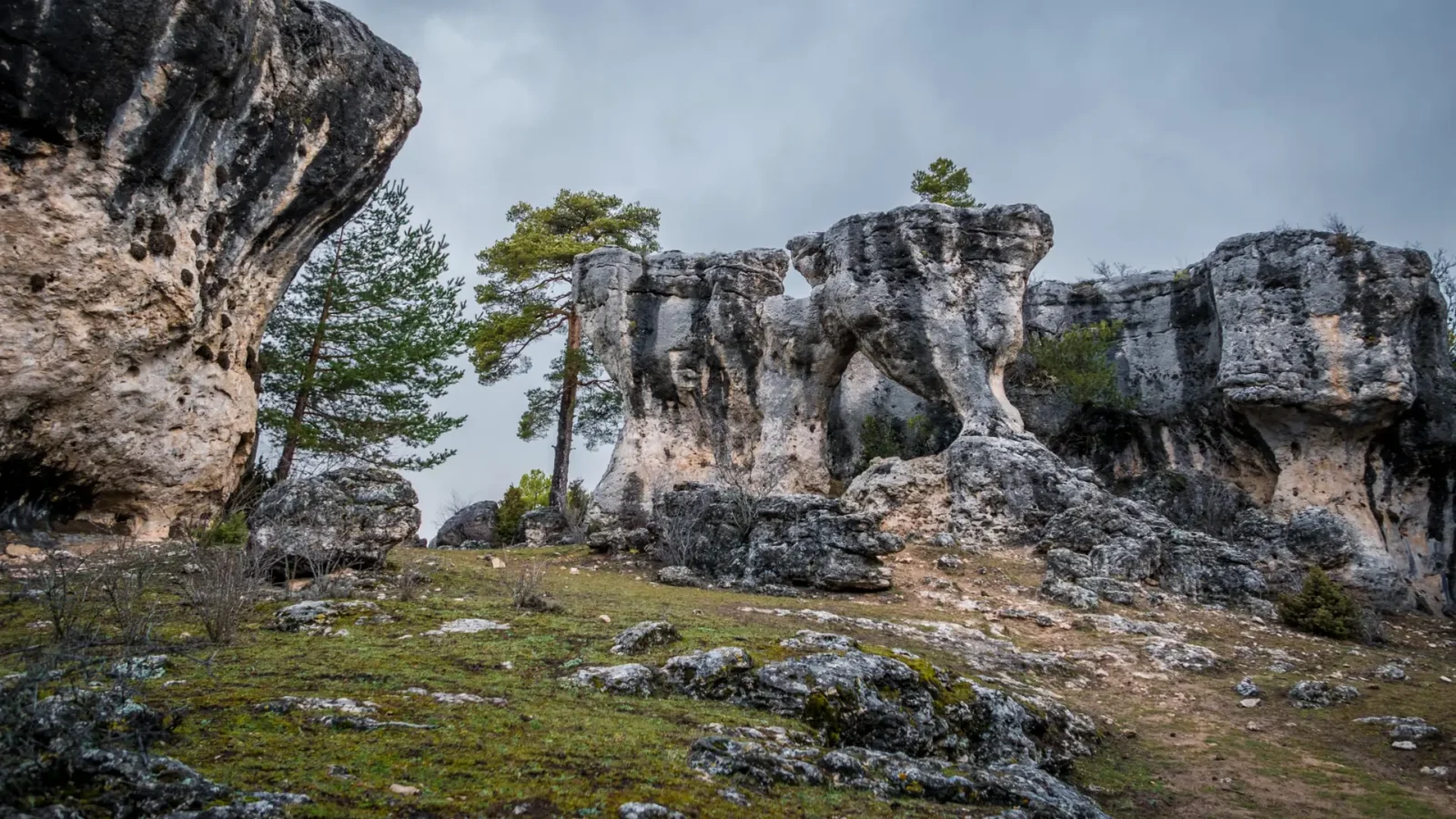
The Serranía de Cuenca is karst country. Over millions of years, water has dissolved and sculpted the limestone into pillars, arches and mushroom-topped towers. The Ciudad Encantada — the "Enchanted City" — is the showpiece. It is a maze of stone shapes with names like the Ships and the Mushroom. But the whole range works this way. The Ventano del Diablo frames the Júcar gorge through a hole in the cliff. The Callejones de las Majadas hide narrow rock corridors. And near the top of the route, two rivers rise from the mountain in waterfalls and mossy pools. Seeing these places in order, over a few slow days, beats rushing one in from the city and driving straight back.
Why it runs one way
This is a linear route: you sleep in a new place each night as you climb. The reason is simple geography. The road runs north from Cuenca deep into the mountains, and the best sights are strung out along it. Driving back to a Cuenca hotel every evening would waste an hour each way. Those winding roads are far better enjoyed in daylight. So the base moves with you: Cuenca on night one, the tiny lakeside village of Uña on night two, and the mountain village of Tragacete on night three. Each stop puts you within a short drive of the next morning's sights. The route also has two natural exits, covered at the end. You can head south-west toward the Don Quixote plains, or further north into the Alto Tajo.
Getting to the start
Cuenca sits in eastern Castilla-La Mancha, where the plains of La Mancha rise toward the mountains. It has no airport of its own, which is part of why the sierra behind it stays so quiet. But it is easy to reach. It even sits on a high-speed rail line, which is unusual for a town this size.
Affiliate note: some links below are affiliate links. If you book through them, we may earn a small commission at no extra cost to you. It helps us keep GoHiddenSpain running and growing. We only suggest services we'd feel comfortable recommending.
Fly into one of these, closest first:
Madrid (Adolfo Suárez–Barajas, MAD)about 170 km, roughly 1 hour 50 minutes by car. The obvious choice: the most flights, the widest connections, and the fastest link of all is the train. Cuenca is on the Madrid–Valencia AVE high-speed line, so a direct AVE from Madrid reaches Cuenca’s Fernando Zóbel station in about an hour. (If you take the train, hire your car in Cuenca — see below.)
Valencia (VLC)about 120 km, roughly 2 hours by car. A good second option, and handy if you want to add the Mediterranean coast to your trip. Valencia is also on the same AVE line, about an hour from Cuenca by train.
Alicante (ALC)about 280 km, roughly 3 hours by car. Worth a look only if the flights or fares beat the other two, or if you are combining this with a longer trip down the east coast.
This is a self-drive route. Pick up a hire car at your arrival airport (or at Cuenca station if you come by train) and keep it until you fly home. There is no useful bus network into the high sierra.
Arriving late? If your flight lands in the evening, sleep near the airport or in Cuenca and start fresh in the morning. The mountain roads north of Cuenca are lovely by day but narrow and unlit at night — there is no reason to drive them tired in the dark.
See our Practical Info page for how to handle late arrivals, plus everything on driving in Spain (low-emission zones, tolls, fuel and parking).
The Itinerary
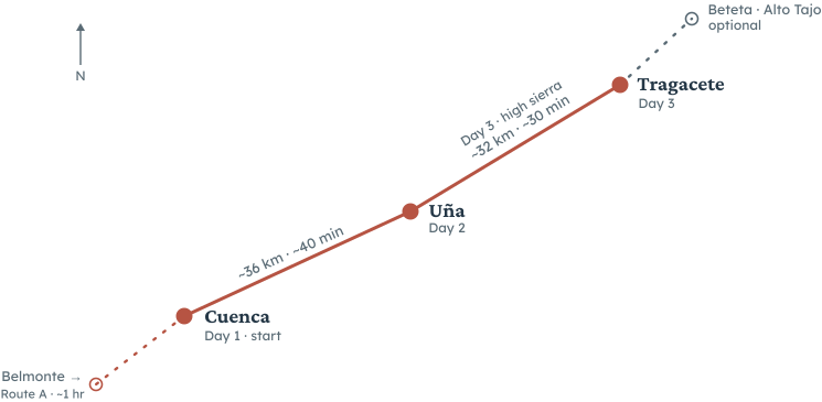
This is a linear drive: three nights, three different beds, always climbing north. The whole run from Cuenca to Tragacete is only about 70 km, so the driving is short — the point is to stop often, walk a little, and let the mountains slow you down. Here is the shape of it.
Day 1 — Cuenca
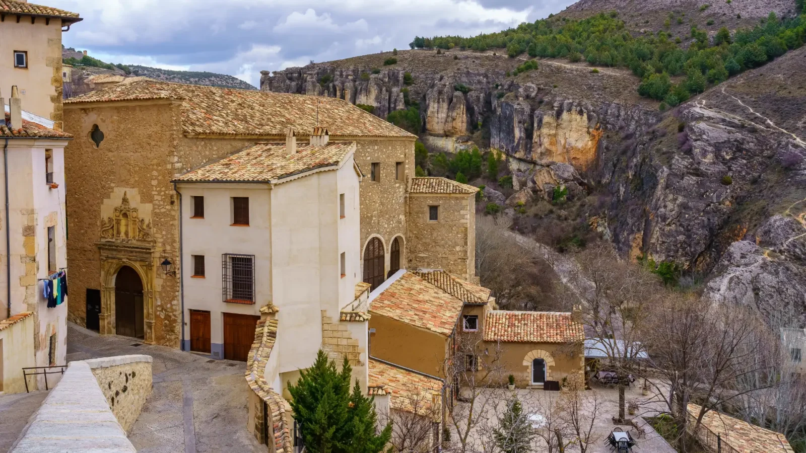
Start in the city itself. Cuenca is a UNESCO World Heritage site, and it is genuinely busy in the middle of the day — tour groups come in for the famous view and leave again by evening. That is the trick to it: stay the night and you get the old town at its best, at dawn and after dark, once the day-trippers have gone. It earns its place on this route as the striking city opening before the empty mountains.
The signature sight is the row of Casas Colgadas, the “hanging houses” that lean out over the gorge on wooden balconies. See them from the Puente de San Pablo, the iron footbridge across the ravine. Above them, the old town climbs to the Plaza Mayor and the cathedral, one of Spain’s earliest Gothic churches. Inside one of the hanging houses is the Museo de Arte Abstracto Español, a small, well-loved collection of modern Spanish art. It is worth an hour even if abstract art is not usually your thing, as much for the building and the view as the paintings. Allow a relaxed full day and an overnight. Wander the upper town in the late afternoon, find a terrace for dinner, and walk back across the bridge after dark when the houses are lit.
Tomorrow you leave the city behind. The road north, the CM-2105, follows the Júcar gorge straight into the mountains.
Tonight you will sleep in CuencaSee where we’d stay.
Day 2 — Uña and the rock country
The driveCuenca → Uña, ~36 km, about 40 minutes on the CM-2105. Winding but easy, and beautiful the whole way as it climbs the Júcar gorge. Where you sleep tonight: Uña.
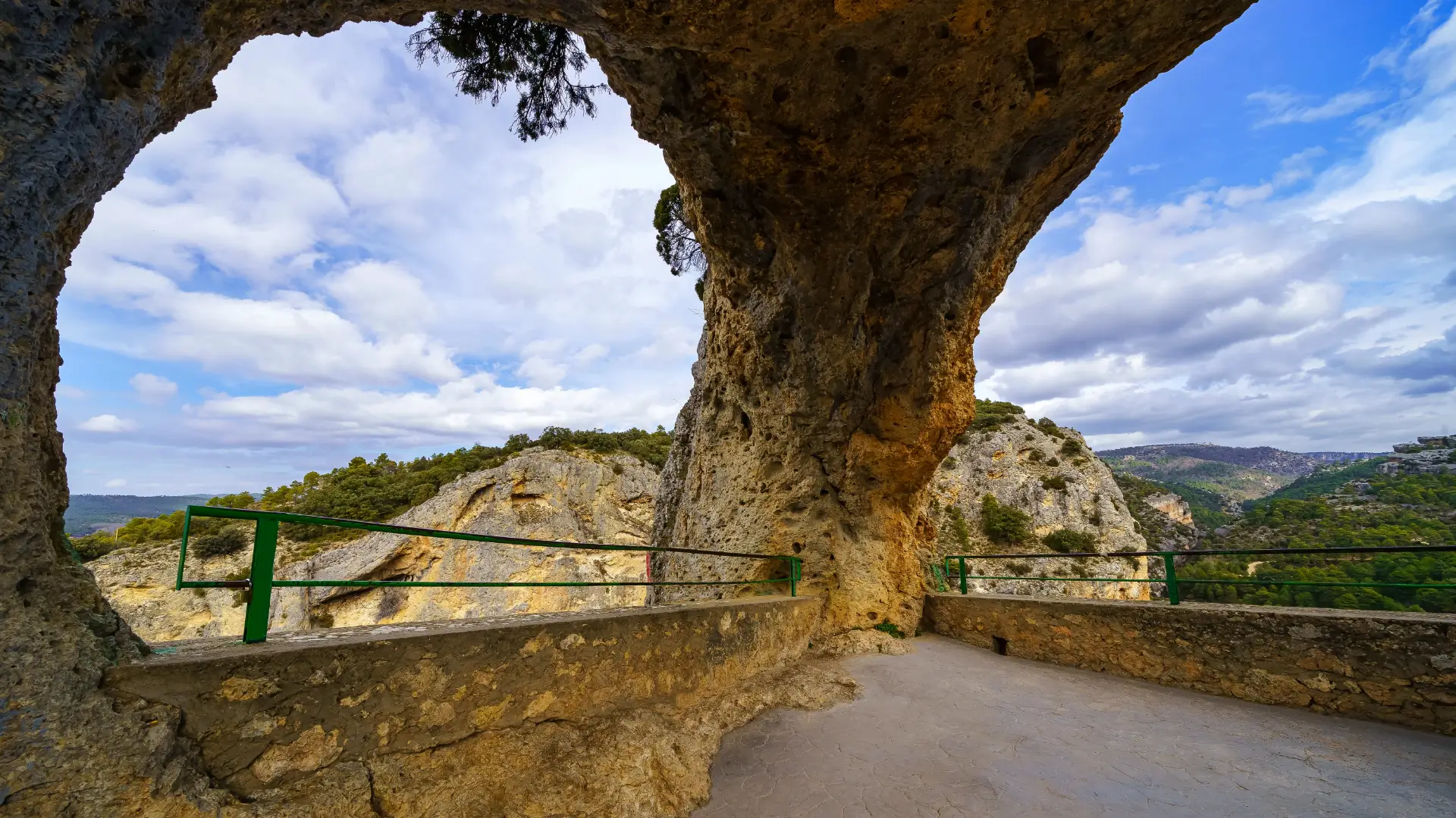
Today is the heart of the route — the day the mountains turn strange and wonderful. Leave Cuenca after breakfast and take the CM-2105 north. You will not get far before the first stop: the Ventano del Diablo (“the Devil’s Window”), a natural gap in the cliff a few minutes off the road, where a short railed path frames a dizzying view down into the Júcar gorge. Five minutes, no walk to speak of, and one of the best views on the whole drive.
From there, turn off toward Valdecabras for the route’s signature sight, the Ciudad Encantada — the “Enchanted City”. This is not a town but a walk through a forest of limestone. Water has shaped the rock into towers, arches and mushroom-topped stones, each with a nickname. The marked circuit is about 3 km on easy, well-signed paths and takes around an hour and a half at a gentle pace. There are information boards at each formation. You buy your ticket at the gate — about €7 for adults. There is no online booking, and card payment is not always possible up here, so bring cash. It is self-guided, so no tour is needed, though a guide can be arranged if you want the geology explained. Allow a relaxed morning. The light is best early, before the mid-morning coaches.
If you still have energy, the nearby Callejones de las Majadas offer a free, quieter version of the same magic — narrow rock corridors and lanes you can wander at will, with no ticket and usually no crowd. It makes a good contrast to the ticketed park next door.
In the afternoon, drop down to Uña, a tiny village wedged between a cliff and its own lagoon, right on the young Júcar. This is your base for the night, and it sits perfectly for tomorrow. If your legs are up for it, take the Escalerón and La Raya walk. It climbs from the village to a run of clifftop viewpoints, looking straight down onto the lagoon and the roofs of Uña. It is a rewarding half-day loop of around 9–10 km, with some steep, stepped sections on wooden staircases bolted to the rock. Vultures often circle at eye level. If you would rather keep it easy, the flat loop around the Laguna de Uña itself is only about 3 km and suits anyone, including families. Either way, end the day by the water in one of the quietest overnight stops in the whole sierra.
TonightYou sleep in Uña. See where we’d stay.
Day 3 — Tragacete and the high springs
The driveUña → Tragacete, ~32 km, about 30 minutes, continuing north on the CM-2105 and CM-2106 deeper into the Serranía Alta. Where you sleep tonight: Tragacete.
This is the high day — the top of the route, where two great rivers are born out of the mountain. From Uña, carry on north into the Serranía Alta. The land opens into high pine forest, and the air is cooler; Tragacete, your base tonight, sits at about 1,281 m, so even in summer the mornings and evenings are fresh.
The morning’s goal is the Nacimiento del Río Cuervo, the source of the River Cuervo, and one of the loveliest spots in the range. It sits near the village of Vega del Codorno, a short drive on from Tragacete. A free, easy trail of about 2 km on boardwalks and forest path leads up to it, taking well under two hours. The path climbs past a spread of small waterfalls — the chorreras — to the mossy cave mouth where the river surfaces. The first stretch of boardwalk is gentle enough for most, and dogs are welcome on a lead. There is no ticket and free parking, and it is open all year. One honest caveat: the falls depend on the season. They are at their fullest in spring, after the snowmelt, and after autumn rains. In a dry late summer or early autumn they can thin to a trickle or nearly dry out. Even then, the spring itself and the forest walk are worth the trip. In hard winter the falls can freeze into a spectacular ice sculpture.
Back near Tragacete, a second, quieter walk leads to the Chorrera del Molino, a roughly 30-metre waterfall on the infant River Júcar. It is about 2 km on foot from the village, across the bridge and up a signed botanical path. Push on a little further, near the San Blas refuge, and you reach the actual Nacimiento del Río Júcar, where the Júcar first rises. It is a hushed, out-of-the-way spot far fewer people reach. These share the Río Cuervo’s seasonal habit: best after rain or snowmelt.
Round off the day in Tragacete itself, a small stone mountain village that makes an unshowy, welcoming base. It has a park interpretation centre worth a quick look, to understand the range you have been driving through. Its kitchens are known for local game — venison and gamo (fallow deer) turn up on menus here in a way they don’t down on the plains. After a day in the high forest, a slow mountain dinner is the right way to end the route.
TonightYou sleep in Tragacete. See where we’d stay.
Extend it: Day 4 — the Hoz de Beteta
The driveTragacete → the Hoz de Beteta, ~40–48 km, about 45 minutes each way, north-west on the CM-210. You sleep a second night in Tragacete — this is a there-and-back day, not a new base.
If the sierra has got under your skin, give it a fourth day. Head north-west to the Hoz de Beteta, a river gorge where the Guadiela has cut walls more than 80 metres high through the limestone. Half the pleasure is the drive. The CM-210 through the canyon was named by a major travel magazine as one of Spain’s ten most scenic roads, so take it slowly and stop at the viewpoints. It is a different landscape from the rest of the route. Here you find a cool, damp, almost northern forest of ancient lime trees, hazels and yews — unusual this far south.
Park at the Casa de la Pradera recreation area and walk the easy, well-signed Paseo Botánico. It is a gentle riverside path through the lime woods to the Fuente de los Tilos spring. Allow a relaxed couple of hours there and back. One thing to know: the side paths to the Cueva de la Ramera and Cueva del Armentero are closed for safety, so stick to the botanical walk and the marked routes. Nearby, the Sumidero de Mata Asnos is a natural swallow-hole where a stream vanishes underground and surfaces again kilometres away — a good short curiosity. With more time, the village of Beteta has timber-balconied mountain houses and the 17th-century Ermita de la Virgen de la Rosa. The 18th-century spa of Solán de Cabras sits in the woods nearby.
One seasonal note, the same as the rest of the route. The small waterfalls run best in spring and after rain. In a dry spell the gorge carries less water, but the cliffs, the forest and the drive are worth it year-round.
TonightA second night in Tragacete?
Where to next
You finish high in the sierra at Tragacete, so don’t just turn around and drive back. You have three genuine onward options:
Chain it to the Don Quixote plainsThis is the big one. Drop back down through Cuenca and carry on south-west to Belmonte, about 96 km, roughly 1 hour 10 minutes from Cuenca. Belmonte, with its great hilltop castle, sits on our route In the Footsteps of Don Quixote. From here you can roll straight onto the windmills-and-plains trip. It is a striking change of scenery: you swap the karst mountains for the wide, flat La Mancha of Don Quixote. Travellers with a week to spare can run the two routes back to back as one trip. It gives the strongest landscape contrast in central Spain — high pine sierra one day, endless plain the next.
Head back for a flight homeReturn to Cuenca (your gateway) and on to Madrid — about 1 hour 50 minutes by road from Cuenca, or an hour by AVE train from Cuenca station. This is the simplest close if your trip ends here.
Push north into the Alto TajoIf you drove the optional Day 4 to the Hoz de Beteta, you’ve already touched the northern edge of the range. The sierra keeps going from there into the great canyons of the upper Tagus and the province of Guadalajara — the Alto Tajo proper. We don’t yet have a route built up there, so treat it as a direction to explore on your own for now; a future Alto Tajo trip will pick up where this one leaves off.
Want the full picture of each town? Each stop links to its own guide above, with every sight, restaurant and place to stay.
Where we’d Stay
One place for each of the nights, in the order you’ll need them.
Parador de Cuenca
Sleep inside history: this Parador fills the former Convent of San Pablo, right across the gorge from the hanging houses, reached by its own footbridge. Recently refreshed, with a quiet courtyard and rooms that look straight at the old town. The Cuenca stay if you can stretch to it.
Check prices & availability for Parador de Cuenca on the accommodation's websiteHotel Uña, Serranía Encantada
A simple, friendly village hotel right by the lagoon, steps from the Escalerón trailhead and well placed for the karst country you saw today. Its restaurant is a bonus in a village this small — handy for dinner after a day on the trails.
Check prices & availability for Hotel Uña, Serranía Encantada on the accommodation's websiteHostal Restaurante Serranía
A family-run mountain hostal in the village, popular with hikers and riders, with its own restaurant — worth knowing here, because Tragacete’s kitchens can close out of season and this one keeps you fed after a day in the high forest. A plain, warm base at ~1,281 m, a short walk from the Chorrera del Molino path and a short drive from the Río Cuervo. Book ahead in autumn (mushroom season) and on long weekends.
Check prices & availability for Hostal Restaurante Serranía on Booking.com
Practical Info
- Driving and roadsThese are quiet regional roads (CM-2105, CM-2106), not motorways. They are well surfaced but winding, with drops in places and few barriers — comfortable in daylight, less fun in the dark or in ice. There are no tolls anywhere on this route.
- FuelFill up in Cuenca before you head north. Petrol stations are scarce in the high sierra; don’t climb toward Tragacete on a near-empty tank.
- ParkingPark below Cuenca’s old town and walk up — the historic centre is tight and partly restricted. At the sights (Ciudad Encantada, Río Cuervo, the Uña walks) there are marked car parks at the trailheads; the Río Cuervo one is free.
- CashBring some. The Ciudad Encantada sells tickets only at the gate and card payment isn’t guaranteed up here; small mountain villages can be cash-first too.
- Altitude and weatherThe high sierra is much cooler than the plains — Tragacete is at ~1,281 m. Pack a warm layer even in July, and check the forecast in winter, when snow and ice are common and some walks get slippery.
- Water in the riversThe waterfalls (Río Cuervo, Chorrera del Molino) are fed by rain and snowmelt. For the fullest flow, come in late spring or after autumn rain; in a dry late summer they can run very low. The springs and the walks are worth it either way — just set your expectations by the season.
- TimingVisit the Ciudad Encantada early to beat the mid-morning coaches. Out here, restaurants keep country hours — lunch is the main meal, and kitchens can close early in the evening in the smallest villages, so don’t leave dinner too late.
- Sturdy shoesFor the stone paths and the stepped Escalerón walk.
- A warm layerEven in summer, the sierra is cold at dawn and dusk.
- WaterOn the longer walks; the river water isn’t drinkable.
Renting a car for the mountains? Compare current deals on LocalRent
We may earn a small commission if you book through this link, at no extra cost to you — it helps us keep this guide growing.Frequently Asked Questions
Three days and three nights covers the route comfortably, from Cuenca up to Tragacete. You can add an optional fourth day as a there-and-back trip to the Hoz de Beteta, sleeping a second night in Tragacete — no extra base needed.
It’s a linear, one-way drive. You sleep in a different place each night — Cuenca, then Uña, then Tragacete — as the road climbs north into the mountains.
Yes. There’s no useful public transport into the high sierra. Hire a car at your arrival airport (or at Cuenca station if you come by train) and keep it for the trip.
Easy but scenic: quiet, well-surfaced regional roads that wind through gorges and pine forest. There are no tolls. The roads are narrow and unlit at night, so plan to drive them in daylight.
Late spring and early autumn are ideal — the waterfalls run well and the forest has colour. Summer is green and pleasantly cool at altitude. Winter is beautiful under snow but cold, with some walks slippery or closed.
Start in Cuenca. Madrid airport is closest by road (about 1 hour 50 minutes) and is also linked to Cuenca by a one-hour AVE high-speed train. Valencia is the next option, about two hours away.
One night each in Cuenca, Uña and Tragacete. Cuenca’s parador has the famous gorge view; Uña and Tragacete offer simple village stays close to the trailheads. Book Tragacete ahead in autumn and on long weekends.
It depends on the season. The Río Cuervo and Chorrera del Molino falls are fullest in spring, after snowmelt, and after autumn rain. In a dry late summer they can run very low or nearly dry, though the springs and the walks are still worth it.
Mostly yes — the roads are fine for a small camper, and there are campsites in the sierra. The one thing to watch is Cuenca’s tight, partly restricted old town, where a large van is awkward; park below and walk up.