
The Emperor’s Valley Route
A four-day drive through La Vera and the Jerte Valley, on the trail of Charles V’s last journey
- Distance~60 km of route driving (Jarandilla → Cuacos → Cabezuela; plus your drive in and out)
- Duration4 days, 3 nights (works as 3 days if rushed)
- Route TypeLinear (the base moves with you — loop-shaped on the map; see “Why linear, not a loop” below)
- Best forCar
- DifficultyEasy driving, one genuine mountain pass (the Puerto del Piornal). Not ideal for a large camper.
- Best seasonLate spring (May — cherry blossom, full rivers) or early autumn (September). Summer for swimming; the winter pass can be cold.
- ThemeHistorical & nature — the retirement and death of Emperor Charles V, across two quiet valleys
- Start / end pointJarandilla de la Vera. Nearest airport: Madrid (about 2¼ hours); Seville and Lisbon also within reach.
Why this Route Exists
In 1556 the most powerful man in Europe gave up his crown and went looking for somewhere quiet to die. Charles V chose this corner of northern Extremadura: the green valleys of La Vera and the Jerte. This route follows his path — and most travellers never come here, which is rather the point. It takes a single, true story and lets it draw a line across two of Extremadura’s quietest valleys.
The emperor's last journey
The history is real and easy to follow on the ground. Charles V, ruler of Spain and the Holy Roman Empire, stepped down in 1556. While his rooms at the Monastery of Yuste were being finished, he stayed in the castle at Jarandilla de la Vera — now a Parador you can sleep in. He then moved the short distance to Yuste, where he lived simply and died in 1558. Walkers still follow the Ruta de Carlos V, the old path he is said to have taken over the mountains from the Jerte Valley down into La Vera. That path is the spine of this trip. You sleep in the castle where he waited, stand in the monastery where he spent his last years, and drive the pass that links the two valleys.
Two valleys, one pass
The two valleys the route joins are worth the drive on their own. La Vera has smoked-paprika fields, half-timbered villages and cold river pools good for a swim. The Jerte has cherry orchards and steep green sides — white with blossom each spring. The road between them climbs over the Puerto del Piornal, past the highest village in Extremadura, which is the one real mountain leg of the trip. You get an emperor's story, two distinct valleys, and a high pass — in four unhurried days, on roads most visitors never find. Bring a swimsuit for the pools and an appetite for smoked paprika.
Getting to the start
This route starts in Jarandilla de la Vera, in the far north-east of Extremadura. The region has no major international airport of its own, which is part of why it stays so quiet. Most travellers fly into one of three larger airports and drive in:
Madrid (MAD)about 2¼ hours by car (~215 km), and the closest big hub by far, with the most international flights. The simplest arrival for this route. There is no direct train to Jarandilla itself; the nearest rail is to Plasencia or Navalmoral de la Mata, then a short drive.
Seville (SVQ)about 3 hours by car (~350 km) up the A-66 to Mérida, then east. A good option if you are pairing this trip with Andalusia.
Lisbon (LIS) about 4¾ hours by car (~475 km), worth considering if it has the cheapest flights for you, or if you are combining Spain with Portugal. (Note: Portugal is one hour behind Spain.)
This is a self-drive route, so you will want a car for the whole trip. The simplest approach is to hire a car at your arrival airport and keep it until you fly home.
Compare car hire on LocalRent for Madrid, Seville or Lisbon airports.
We may earn a small commission if you book through this link, at no extra cost to you.Arriving late? If your flight lands in the evening, it is often more relaxing to spend the first night near your arrival airport and start the drive fresh the next morning, rather than tackling an unfamiliar road in the dark. See our Practical Info page for how to handle late arrivals, plus everything on driving in Spain (low-emission zones, tolls, fuel and parking).
The Itinerary
This is a linear route: you move with it. You sleep two nights in La Vera (Jarandilla), using the second day to explore nearby without packing up, then cross the pass and sleep your last night on the Jerte side (Cabezuela). On the map it looks like a loop, because you can drop down the Jerte Valley toward Plasencia to drive home — but the sleeping rhythm moves you forward, valley to valley, the way the emperor went. (Prefer to settle in one place and day-trip out instead? That is the single-base option — see the Extremadura region guide for choosing a base.)

Day 1 — Jarandilla de la Vera
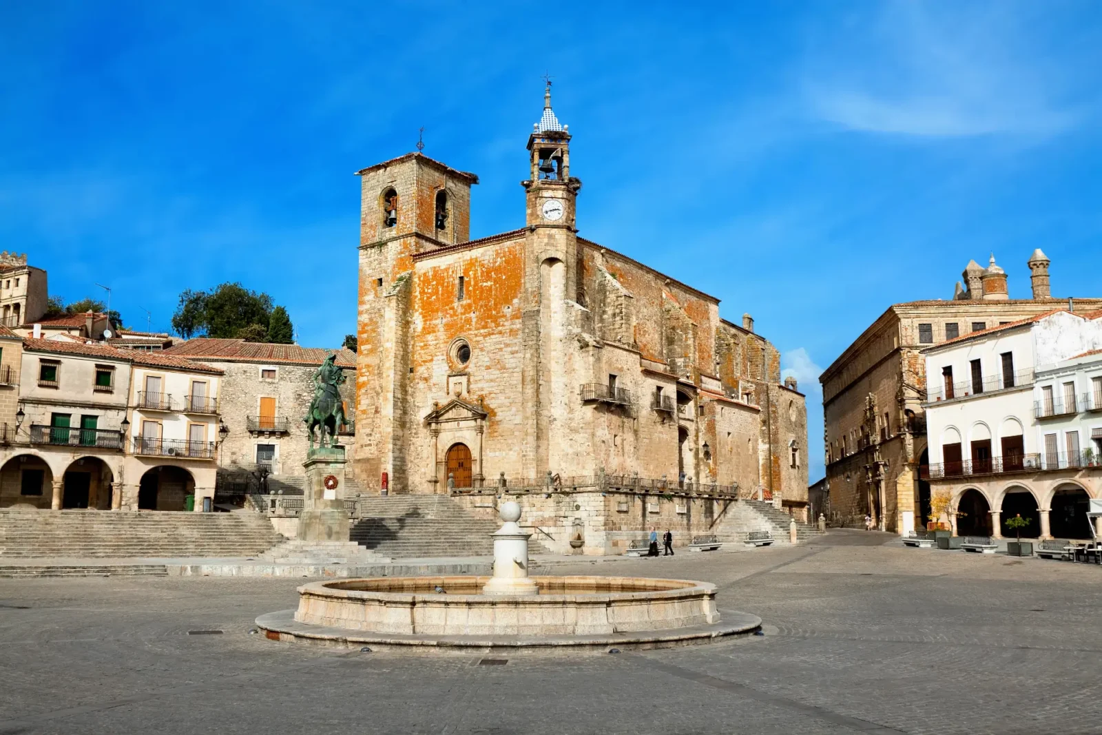
Start where the emperor waited. Jarandilla de la Vera is a working La Vera town built around a 15th-century castle — the Castle of the Counts of Oropesa, now a Parador. Charles V lived here in 1556 and 1557 while Yuste was made ready. Allow a relaxed afternoon: look round the castle courtyard, walk up to the Church of Santa María de la Torre, and cross the old Parral bridge on the edge of town.
Then do the thing the guidebooks forget — go to the water. The Garganta Jaranda runs cold and clear right below town, with natural pools good for a swim or a riverside sit. Pack a swimsuit. Eat slowly in the old quarter and let the day’s visitors leave; the lit castle and quiet lanes after dark are the best of the town.
Watch-out: the river pools are mountain-fed and genuinely cold, and rocks can be slippery — fine for a dip, not for diving.
Full detail on Jarandilla de la Vera
TonightYou sleep tonight in Jarandilla de la Vera (first of two nights in La Vera).
Day 2 — Cuacos de Yuste & the Monastery of Yuste
Drive: Jarandilla → Cuacos de Yuste, ~9 km, about 15 minutes. You keep your room in Jarandilla — today is a day-trip, no repacking.
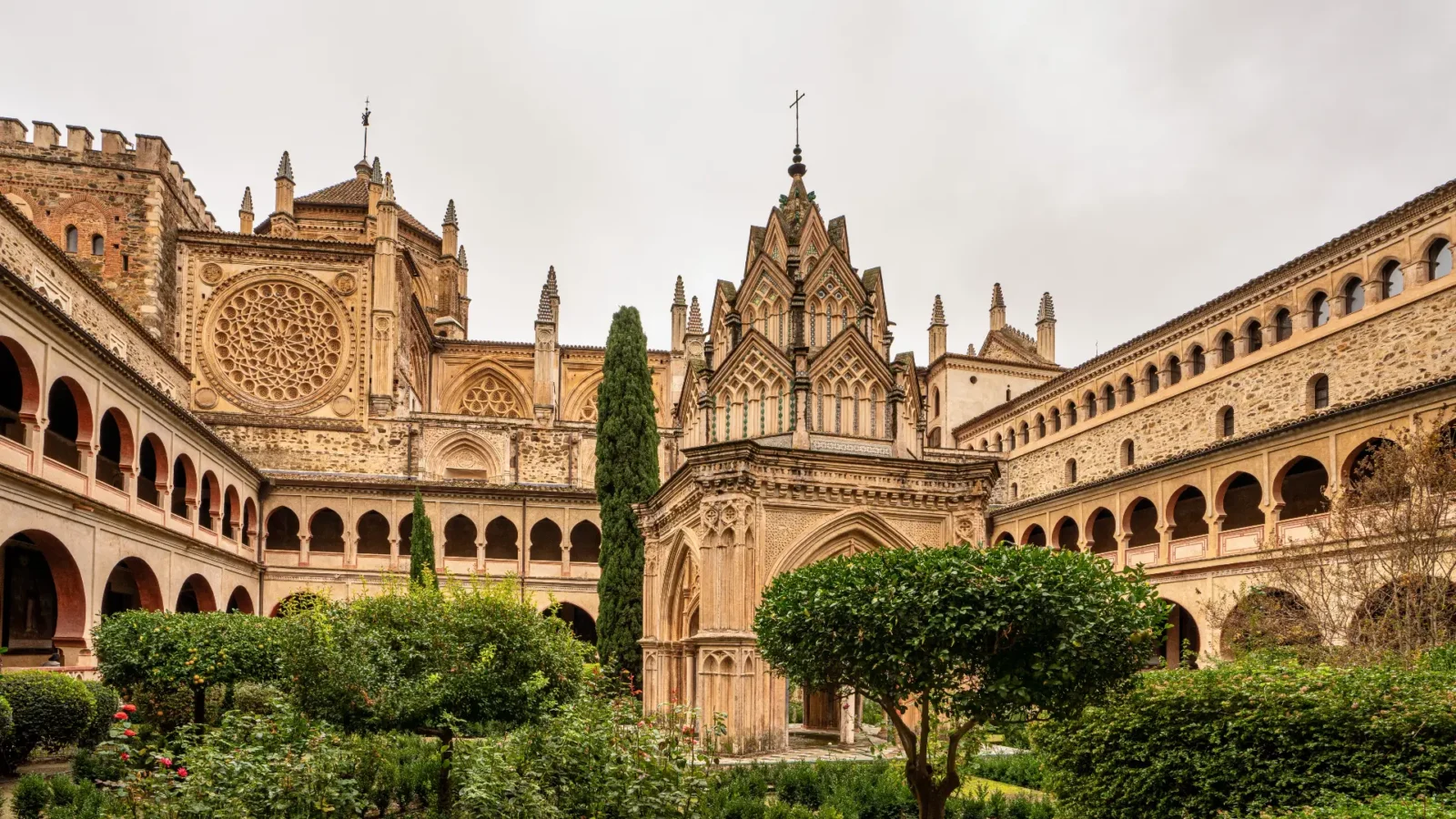
This is the heart of the story. Cuacos de Yuste is a tiny, handsome La Vera village of stone and timber, and just above it stands the Monastery of San Jerónimo de Yuste, where Charles V spent his final two years and died in 1558. Allow a relaxed half-day: the monastery and its imperial apartments deserve unhurried time, and the village plaza below rewards a slow coffee. In the village, look for the Casa de Jeromín, linked to the emperor’s son, Don Juan de Austria.
With the afternoon free, stay close. The mountain village of Garganta la Olla, a short drive up toward the pass, is one of La Vera’s prettiest — narrow lanes, the famous blue-painted house, and good walking. Or head back to the Garganta Jaranda or another of La Vera’s river pools for a second swim.
Watch-out: Yuste is run by Patrimonio Nacional and can close on certain days and over the midday break — check opening times on the day, and note that buying a guided visit is the only way into some rooms.
Day 3 — Over the Puerto del Piornal to Cabezuela del Valle
Drive: Jarandilla / La Vera → over the Puerto del Piornal → Cabezuela del Valle, ~50 km, about an hour. This is the route’s one real mountain leg — a winding road that climbs from La Vera through Garganta la Olla, over the pass by Piornal (the highest village in Extremadura, about 1,175 m), then drops in long curves into the Jerte Valley and down to the N-110. Take it slowly; it is the most scenic driving of the trip.
This crossing is the route. It traces, by road, the Ruta de Carlos V — the mountain path the emperor’s party is said to have used between the valleys. Stop at a viewpoint near the top for the long view back over La Vera, and again on the way down for your first sight of the Jerte’s terraced orchards.
Arrive in Cabezuela del Valle with the afternoon ahead. It has the best-kept old quarter in the valley: a tight medieval casco antiguo and a former judería (Jewish quarter) of leaning timber houses, plus a riverside walk along the Jerte. Allow a slow couple of hours on foot, then settle in for the night on the Jerte side.
Watch-out: the pass is high. In winter it can be cold, foggy or, rarely, snowy — check conditions before you set off, and don’t attempt it after dark if you can avoid it.
Full detail on Cabezuela del Valle
TonightYou wil be staying in Cabezuela de Valle
Day 4 — The Jerte Valley, and where to next
Give the morning to the Jerte before you decide where you’re going. In spring (roughly late March), the whole valley turns white with cherry blossom — one of Spain’s great seasonal sights, and the reason to time the trip for May if you can. The rest of the year, the orchards, the river and the Reserva Natural Garganta de los Infiernos (with its famous rock pools, Los Pilones) are reason enough to linger. Buy a box of Jerte cherries from a doorway in June if you pass through then.
If you have an extra hour, drive up to Tornavacas at the top of the valley. It marks the start of the original walking Ruta de Carlos V — a fitting place to finish a trip that has followed the emperor’s road all the way down.
Where to next
This route ends in the Jerte Valley with the road open in three directions. Whichever you choose, you drop down the valley on the N-110 to Plasencia first (~32 km, about 35 minutes) — the natural gateway out of the area. From there:
Carry on through ExtremaduraPlasencia puts you on the road south to Cáceres (about 1¼ hours from Cabezuela), where our Medieval Loop route begins. The two trips link cleanly into a week of Extremadura: emperors and valleys first, medieval cities next.
Head back eastMadrid is about 2¾ hours from the valley — easy for a flight home or the end of a longer Spanish trip.
Continue northThe A-66 corridor by Plasencia runs up toward Salamanca and Castilla y León (roughly 1¾–2 hours), if your trip carries on into central-western Spain.
Want the full picture of each town? Each stop links to its own guide above, with every sight, restaurant and place to stay. See how this route pairs with the Medieval Loop .
Where we’d Stay
This is a moving trip, so we give you one strong, bookable pick per overnight — enough to lock in the night you’re reading about. For the full range across every budget, each pick links through to that town’s own guide.
Parador de Jarandilla de la Vera
Sleep inside the castle where Charles V waited out his last months — towers, a moat, a Gothic courtyard and an outdoor pool among olive and orange trees. Recently restored, it pairs medieval walls with full modern comfort, and its restaurant turns out hearty Extremaduran cooking. The headline stay of the whole cluster.
Check prices & availability for Parador de Jarandilla de la Vera on the accommodation's websiteCasa De Aldaca Rural
A beautifully restored 1810 house in Jerte, run with real care — fireplaces, a garden, a generous breakfast and a calm, grown-up feel. The standout small stay in the valley for couples who want something special.
Check prices & availability for Casa De Aldaca Rural on the accommodation's website
Practical Info
- Driving and roads: This is an easy route to drive, with one exception: the Puerto del Piornal crossing on Day 3 is a genuine mountain pass — narrow in places, lots of curves, slow going. Allow more time than the distance suggests and enjoy it rather than rushing. The rest is gentle valley road. No toll roads anywhere on the route.
- The pass in winter: The Piornal pass sits high (Piornal is the highest village in Extremadura). It can be cold, foggy, or briefly snow-affected in winter. Check conditions before crossing, and avoid it after dark in poor weather. From roughly late autumn to early spring, allow extra margin.
- Fuel & services: Fill up in a larger town (Jarandilla, Jaraíz de la Vera or, on the Jerte side, Cabezuela/Plasencia) before the pass — the high villages have few or no services. Distances are short, but mountain roads use more fuel than the map implies.
- Parking and old quarters: Park at the edge of the old quarters in Jarandilla and Cabezuela and walk in; the medieval lanes are tight and not built for cars. There are no big-city low-emission zones (ZBE) on this route — those apply to cities like Madrid, not these villages.
- Timing and opening hours: Sights and small restaurants often close over the long midday break and on one weekday. The Monastery of Yuste keeps its own hours and closing days — check on the day rather than relying on a fixed timetable. Time the whole trip for May (cherry blossom, full rivers) or September (warm, quiet) for the best of it.
- Water: The river pools (gargantas) are mountain-fed and cold even in summer, with slippery rocks. Lovely for a dip; take care.
- A swimsuit and quick-dry towel: The river pools are the quiet highlight of La Vera.
- Layers for the pass: It can be 10°C cooler at the top than in the valleys, in any season.
- Sturdy shoes: For the cobbled old quarters and a short riverside or garganta walk.
- Download offline maps before you go: Mountain villages can have patchy signal.